olgalolo
Russian Federation

I'm part of a small local charity we hold an annual illuminated carnival which travels a route from our start point one side of the town, through the center and out the other side.
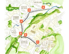
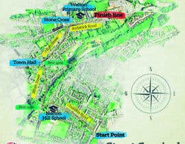
We need a route map that shows the route to include the start , finish and various landmarks in a traditional watercolour design, like the one attached that was done for the town park.
The start point is very just after turning in to Charlton Road from the A367 (this is needed on the map), it then travels past Norton Hill School (landmark required on map) just after this is the rest area which goes around the corner into Silver Street and finishes just past the old train station (rest area and station required on map). At the bottom of silver street by the Town Hall (required landmark) we turn in to the High Street and up to the junction with Radstock Rd, known locally as Stones Cross (required landmark). Next we travel towards Radstock on Radstock road past Welton Primary School (required landmark) with the finish line just slightly further up the road (finish point required on map)
Route details and information here: https://illuminatedcarnival.co.uk/important-event-information/
Local Area Map: https://www.google.co.uk/maps/@51.2828651,-2.4801429,15z?hl=en&authuser=0
Required as a high res jpg image with exact locations of landmark to be agreed as require. Preference will be given to those who submit an actual outline design but examples of other work also welcome.
Thanks
“Very happy!”
![]() SteveCollins77, United Kingdom.
SteveCollins77, United Kingdom.

จัดการประกวดของคุณ รวดเร็วและง่ายดาย

รอรับผลงานจำนวนมหาศาล จากทั่วโลก

มอบรางวัลให้แก่ผลงานที่ดีที่สุด ดาวน์โหลดไฟล์ - ง่ายดาย!